|
The collection of accurate location coordinates along with quality biological data is crucial to the All Taxa Biodiversity Inventory (ATBI) program. This location data, compiled into species distribution maps, will allow Park staff to better manage these species against environmental and other threats, and assist scientists studying species’ habitat requirements or other spatial patterns. To enable the Great Smoky Mountains National Park to efficiently and accurately add your location data to the ATBI Database and its Geographic Information System (GIS), please follow the guidelines listed below when recording locations and submitting data.
Tutorials and other tools for using GPS are available at: |
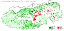
Distribution map of two fern species developed from point location data. |
|
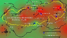
Map of ozone levels derived through computer modeling. |
1. Recommended Map Coordinate System
UTM Coordinates:
- UTM coordinates are preferred over latitude-longitude or any other types of coordinates.
- Use UTM Zone 17, even for the far western tip of the Park (Tallassee quadrangle), which is in Zone16.
- The preferred datum is NAD83, which is the current standard for the ATBI Database and the Park’s GIS data, and is still the datum of all USGS topographic maps for the Park.
- Record UTM Easting coordinates to 6 digits (leave off any preceding zeros), and UTM Northings to 7 digits. Record whole numbers only; no decimal places (which represent fractions of a meter), no commas (thousands separators), and no letters (such as ‘E’ or 'N’).
- For example: The UTM coordinates of Sugarlands Visitor Center would be recorded as “270430” (no quotes) for the easting and “3951817” for the northing.
Latitude-Longitude Coordinates:
- If you are unable to collect UTMs, please record/submit Latitude-Longitude (Geographic) coordinates in one of the following three formats:
| Description | Data Format | Example |
| decimal degrees | DD.DDDDD | 35.20181 |
| degrees and decimal minutes | DD MM.MMM | 35 12.108 |
| degrees, minutes and seconds > | DD MM SS.S | 35 12 06.5 |
- The decimal degrees format is preferred, followed by the degrees-minutes-seconds format.
- The preferred datum for lat-long coordinates is also NAD83.
- Record coordinate values to the number of significant decimal places shown above (or more).
- When submitting data, do not enter symbols (other than decimal points), and leave a single space between the degrees, minutes and seconds units.
- Do not use more than one format within the same set of data.
* * Note: NAD83 is now the Park standard. However, any data that has already been entered can be NAD27,
but must be noted as such. All new GIS data must be taken with the GPS unit set at NAD83. Fortunately, this is commonly
the default for new units. * *
2. Setting your GPS Unit
Note: The following instructions are for a typical Garmin unit; however, most other brands are set up in a similar manner. See your instruction booklet for further assistance.
Setting your GPS unit to UTM (Zone 17), NAD83:
|
1. From the main menu, navigate to the Setup page (submenu) and then to the Position tab (or Units page on eTrex’es). Select UTM/UPS* for the Position Format . . . * UPS = Universal Polar Stereographic (used in the polar regions instead of UTM) |
|
2 . . . and then NAD83 CONUS* for the Map Datum. (Note: The UTM Zone number is not selectable, but rather is automatically calculated by the GPS unit based on your current location, and displayed next to the easting and northing coordinates). * CONUS = Contiguous United States |
|
3. Check your position settings before each use, especially when the GPS unit is shared with others. But if you do collect data using settings different than above, be sure to record the Position Format and Datum settings used (and any Zone other than 17 – see below). This information is needed to convert your data into the correct coordinate system. |
|
4. The easting and northing coordinates displayed, for example, could be recorded as 242375 and 3941874, respectively. Also record the UTM Zone number if it is not 17, to allow conversion of your data into the correct coordinate system. *The “17 S” displayed on the GPS screen refers to north-south zone (column) “17” and east-west band (row) “S” in the UTM grid system. |
3. Converting Existing Coordinates to UTM (NAD83)
Here are some of the methods available for converting latitude-longitude (or other) coordinates to (and from) UTM.
- GPS manufacturers’ software (e.g., Garmin’s MapSource and US Topo) usually allows you to download and export your data into any coordinate system (regardless of the settings on your GPS unit). Check your GPS manufacturers’ web site for more information.
- The same capabilities are available in many third-party GPS/mapping programs, including:.
- DNR Garmin is a free software program that will download and convert data from Garmin GPS units. The program can be downloaded from the Minnesota Department of Natural Resources GIS web site. Note: DNR Garmin is now a stand-alone program and no longer requires ArcView (GIS software)
- Corpscon is an excellent free software utility from the Army Corps of Engineers which will convert coordinates between UTM, lat-long and State Plane systems, and NAD27 and NAD83 datums. Point coordinates can be converted manually (one at a time), or automatically in a batch files. Corpscon will also convert lat-long coordinates into all three formats.
- Go to the Army Corps of Engineers Coordinate Conversion web site:
- Then download the basic program installation file:
- “corpscon_base_conus.exe”
- “corpscon_base_conus.exe”
- Hints for using Corpscon:
- Don’t enter the minus sign in front of longitude values (e.g., “-83.123” should be entered as “83.123” [no quotes]). Corpscon assumes all users are in the western hemisphere, where longitude values are technically negative (unless they’re described as “83.123 degrees west”, for example).
- The output values will usually be to several decimal places. Round off these numbers using the guidelines in the first section of this document.
- Corpscon does not have an option for the WGS84 datum, so instead select NAD83 (the resulting error should be less than a meter).
- “None” should be selected for the vertical datum (and ignore the vertical datum units field), otherwise you may get strange results. (Vertical datums are only needed when making precise elevation measurements; i.e., not necessary for our purposes).
- If you have further questions, contact the staff at Discover Life In America.